Is winter 2.0 coming to Western Canada? Your snow forecast for February-March 2026
Weather expert Kyle Brittain breaks down the snow forecast for Alberta and BC for February through March 2026.
Will we get a winter 2.0? What will it look like? Naturally, after a strong start to the 2025-26 ski season followed by warm "June-uary" conditions, that question is top of mind for skiers and snowboarders in Western Canada.
So what will the weather hold for Alberta and BC going into the second half of the ski season? Will we get more snow, will it return to seasonal temperatures or remain warm? Let's dive in.
State of the snowpack
First let’s address where things are at now, given that it will be the foundation for what's to come.
As the calendar flips to February, mountain snowpacks are in good shape throughout many areas of western Canada.
According to the Government of British Columbia’s snow conditions summary on January 15, the provincial average across all automated snow weather stations was at 127% of normal.

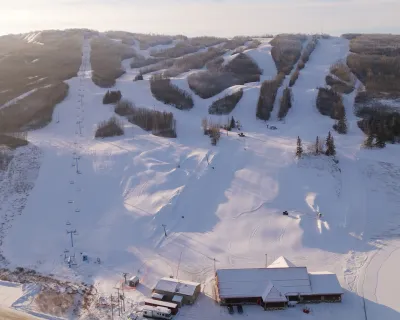
Photo:
Savannah Robinson
Powder King got hammered in late December and early January, leaving it like this!
The most snow relative to normal exists across much of northern British Columbia and the Central Coast.
Other ranges across the south are also seeing above normal snow packs, including areas of the Similkameen, Boundary, the Columbia/Kootenays, and in the Rocky Mountains of both British Columbia and Alberta.
Some snow stations in Banff National Park are seeing more snow than at any time last season and continue to run well-above normal for the time of year, thanks in large part to a very stormy December.

Photo:
Jim Barr
Lake Louise recorded its best start in 75 years.
The mountains of the South Coast and Vancouver Island, however, are seeing below normal snow packs thanks to a series of warm, moist atmospheric river events in December and January that brought high freezing levels and high-elevation rainfall. This resulted in melting.
Occasional, strong upper ridging also led to long periods with limited precipitation. In places like Vancouver and Victoria, cherry blossoms have emerged several weeks early.
score better snow days with SnowSeekers
sign up for the FREE newsletter that gets you into the snow
For the most part, though, this winter has brought more classic La Niña conditions across the rest of western Canada, with cooler and wetter conditions than normal prevailing in many areas.
The good news is, these conditions could persist for most areas as we round out the rest of winter.
Snow & weather outlook for Feb - Apr
As always when making a seasonal forecast, we look to important climate drivers that can shape the global circulation and drive prevailing winter storm tracks.
A weak La Niña has been present this winter, characterized by colder than normal sea surface temperatures in the central and eastern equatorial Pacific Ocean.
This pattern tends to favour cooler than normal conditions across western Canada during the winter, with wetter than normal conditions in the mountains of British Columbia and Alberta.

Weather map showing temperature variations across North America, indicating cooler conditions across Western Canada.
During the January to March period, forecasts indicate the transition to ENSO neutral conditions (neither La Niña nor El Niño), although La Niña conditions will likely linger through the rest of winter.
Closer to home, sea surface temperature patterns across the North Pacific have been relatively similar over the past few years—with much warmer than normal conditions in the western and central North Pacific.
This can help us find “analogs” of other years that had similarities in the climate system to what we have this year, increasing forecast confidence.

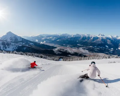
Photo:
Marty Clemens
While not overly strong, perhaps the best analog for this year’s February through April period may be that of 2023.
That year also saw a transition from a weak La Niña to neutral conditions by late winter, and on into El Niño conditions by early summer, similar to what forecasts show for this year.
The 2023 season had cooler than normal temperatures across western Canada, with wetter than normal conditions along the central BC coast and drier than normal conditions persisting along the South Coast. Near-normal precipitation occurred elsewhere across western Canada.
Long range model ensemble forecasts take a slightly more optimistic approach, supporting the notion that snowier than normal conditions will prevail across much of the West, especially in the mountains of southern British Columbia and southwestern Alberta.

The long range model above suggests an above-normal precipitation pattern for Jan-Mar in Western Canada.
They also show cooler to near-normal temperatures generally persisting through the rest of winter across western Canada.
A return to more wintry conditions appears likely by mid-February, ushering in colder and potentially snowier-than-normal conditions through early spring.
All this is to say that excellent skiing conditions will likely be had in many areas of western Canada through the rest of winter, even if it means venturing inland from the south coast.
Here’s to beefing up the winter snowpack even more. Play safe out there!
Kyle Brittain is an Alberta-based weather expert and frequently appears on CBC Radio to explain weather phenomena. You can find his reports and updates on Facebook @badweatherkyle.
More snow info
Sign up for our free SnowSeekers newsletter to connect to the snow community in Western Canada, NEW for 2026 we are introducing snow forecasting to keep you not just in the snow, but ahead of the snow.
Sign up now, and read on for more skiing stoke.